Musselshell River near Lavina
Future / Actual / Minor
OWP 2.0 WWA Modal Title
01/11/2021, 10:04 PM UTC through 01/11/2021, 10:04 PM UTC
Sender
Sent
- Monitored seasonally - readings not available during winter months.
Official
CATEGORY STAGE 
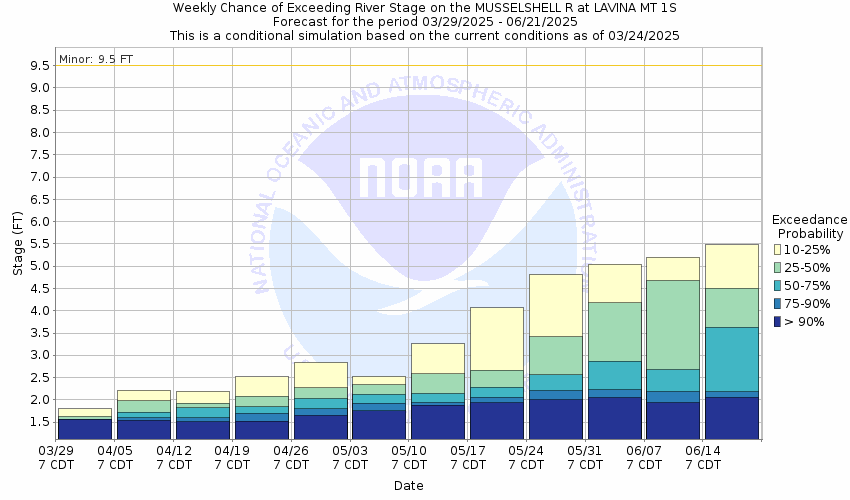
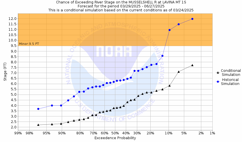
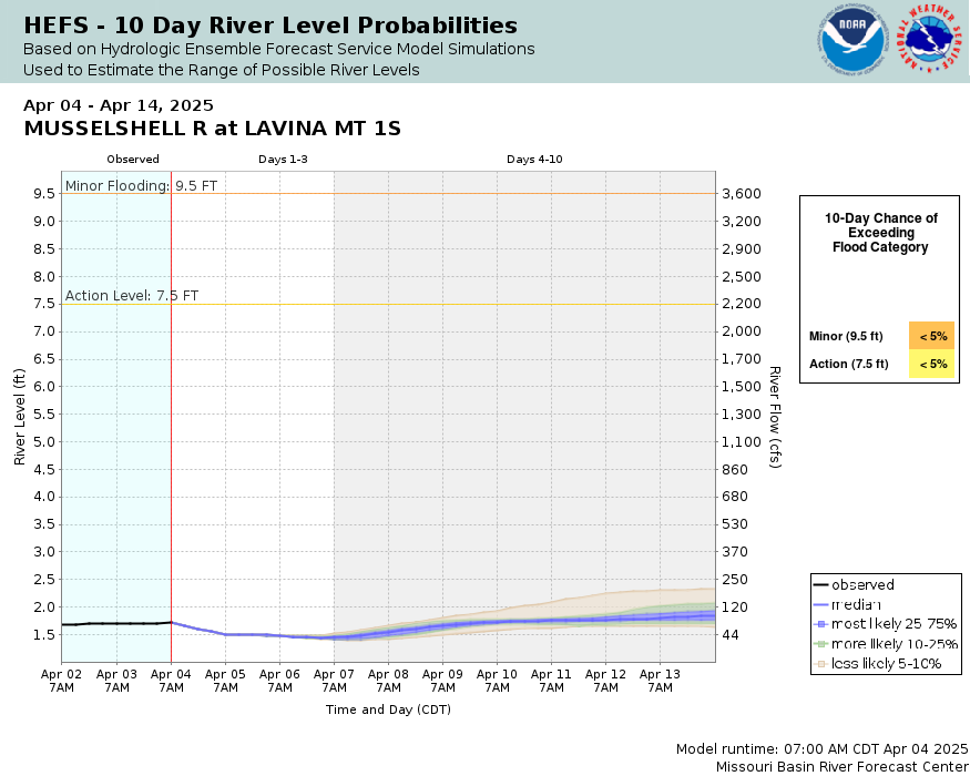
Minor Flooding 9.5 ft - Monitored seasonally - readings not available during winter months.
National Water Model Hydrograph
Official NWS streamflow forecasts are produced by NWS hydrologic forecasters for river gauge locations using hydrologic models which are calibrated to that location. This process considers additional guidance and information, including local expertise and experience, to produce the best forecast possible. The NWM output provides supplemental guidance to NWS forecasters and should not be considered an official NWS river forecast.
Gauge Info
| Coordinates | 46.2891, -108.938 |
| RFC | MBRFC |
| State | MT |
| WFO | BYZ |
| County | Golden Valley |
| Data Provider(s) | |
| US Geological Survey | USGS--Water Resources of the United States |
| USGS | 06125600 |
Gauge Location
Recent Crests
| 1. | 2.86 ft | on 06-01-2024 |
| 2. | 9.45 ft | on 06-07-2023 |
| 3. | 3.16 ft | on 06-04-2022 |
| 4. | 5.81 ft | on 05-22-2020 |
| 5. | 9.06 ft | on 05-29-2019 |
Recent Crests
| 1. | 2.86 ft | on 06-01-2024 | |
| 2. | 9.45 ft | on 06-07-2023 | |
| 3. | 3.16 ft | on 06-04-2022 | |
| 4. | 5.81 ft | on 05-22-2020 | |
| 5. | 9.06 ft | on 05-29-2019 | |
| 6. | 11.15 ft | on 06-21-2018 | |
| 7. | 4.04 ft | on 06-15-2017 | |
| 8. | 2.91 ft | on 07-11-2016 | |
| 9. | 7.84 ft | on 06-05-2015 | |
| 10. | 10.47 ft | on 03-10-2014 | |
| 11. | 3.73 ft | on 06-14-2013 | |
| 12. | 3.43 ft | on 05-28-2012 | |
| 13. | 14.04 ft | on 05-25-2011 | 1 |
| 14. | 6.07 ft | on 06-22-2010 | 1 |
| 15. | 4.85 ft | on 07-03-2009 | 1 |
| 16. | 4.97 ft | on 05-25-2008 | 1 |
| 17. | 4.07 ft | on 07-09-2007 | 1 |
| 18. | 4.21 ft | on 06-12-2006 | 1 |
| 19. | 5.35 ft | on 06-29-2005 | 1 |
| 20. | 3.86 ft | on 06-14-2004 | 1 |
| 21. | 3.83 ft | on 07-11-2003 | 1 |
| 22. | 3.64 ft | on 06-05-2002 | 1 |
| 23. | 4.02 ft | on 06-27-2001 | 1 |
| 24. | 3.78 ft | on 07-10-2000 | 1 |
| 25. | 4.33 ft | on 06-01-1999 | 1 |
| 26. | 4.50 ft | on 06-22-1998 | 1 |
| 27. | 11.13 ft | on 06-14-1997 | 1 |
| 28. | 5.97 ft | on 06-02-1996 | 1 |
| 29. | 6.89 ft | on 06-08-1995 | 1 |
| 30. | 4.78 ft | on 04-27-1994 | 1 |
| 31. | 5.62 ft | on 07-27-1993 | 1 |
| 32. | 5.86 ft | on 06-19-1992 | 1 |
Historic Crests
| 1. | 14.04 ft | on 05-25-2011 | 1 |
| 2. | 11.15 ft | on 06-21-2018 | |
| 3. | 11.13 ft | on 06-14-1997 | 1 |
| 4. | 10.47 ft | on 03-10-2014 | |
| 5. | 9.45 ft | on 06-07-2023 |
Historic Crests
| 1. | 14.04 ft | on 05-25-2011 | 1 |
| 2. | 11.15 ft | on 06-21-2018 | |
| 3. | 11.13 ft | on 06-14-1997 | 1 |
| 4. | 10.47 ft | on 03-10-2014 | |
| 5. | 9.45 ft | on 06-07-2023 | |
| 6. | 9.06 ft | on 05-29-2019 | |
| 7. | 7.84 ft | on 06-05-2015 | |
| 8. | 6.89 ft | on 06-08-1995 | 1 |
| 9. | 6.07 ft | on 06-22-2010 | 1 |
| 10. | 5.97 ft | on 06-02-1996 | 1 |
| 11. | 5.86 ft | on 06-19-1992 | 1 |
| 12. | 5.81 ft | on 05-22-2020 | |
| 13. | 5.62 ft | on 07-27-1993 | 1 |
| 14. | 5.35 ft | on 06-29-2005 | 1 |
| 15. | 4.97 ft | on 05-25-2008 | 1 |
| 16. | 4.85 ft | on 07-03-2009 | 1 |
| 17. | 4.78 ft | on 04-27-1994 | 1 |
| 18. | 4.50 ft | on 06-22-1998 | 1 |
| 19. | 4.33 ft | on 06-01-1999 | 1 |
| 20. | 4.21 ft | on 06-12-2006 | 1 |
| 21. | 4.07 ft | on 07-09-2007 | 1 |
| 22. | 4.04 ft | on 06-15-2017 | |
| 23. | 4.02 ft | on 06-27-2001 | 1 |
| 24. | 3.86 ft | on 06-14-2004 | 1 |
| 25. | 3.83 ft | on 07-11-2003 | 1 |
| 26. | 3.78 ft | on 07-10-2000 | 1 |
| 27. | 3.73 ft | on 06-14-2013 | |
| 28. | 3.64 ft | on 06-05-2002 | 1 |
| 29. | 3.43 ft | on 05-28-2012 | |
| 30. | 3.16 ft | on 06-04-2022 | |
| 31. | 2.91 ft | on 07-11-2016 | |
| 32. | 2.86 ft | on 06-01-2024 |
Gauge Photos
No Images Found

Unique Local Info
Collaborative Agencies
The National Weather Service prepares its forecasts and other services in collaboration with agencies like the US Geological Survey, US Bureau of Reclamation, US Army Corps of Engineers, Natural Resource Conservation Service, National Park Service, ALERT Users Group, Bureau of Indian Affairs, and many state and local emergency managers across the country. For details, please click here.
Resources
Hydrologic Resource Links
- River Forecast Centers
- Text Products
- Past Precipitation
- Forecast Precipitation
- USGS MT/WY Streamflow Conditions
- NRCS-MT Water Supply Outlook Reports
- NRCS-WY Water Supply Outlook Reports
- NRCS Wyoming Snow Survey
- NRCS Montana Snow Survey
- State of Wyoming Stream Gages
- State of Montana Stream Gages
- Drought Monitor
- NOHRSC Snow Information
- Inundation Mapping Locations