The National Water Model

NWM Operational Configuration:

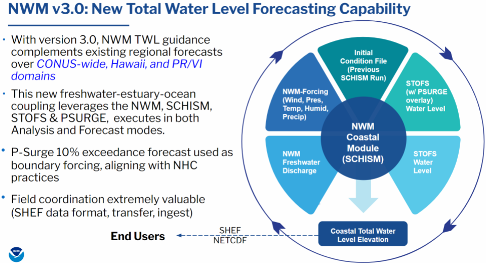
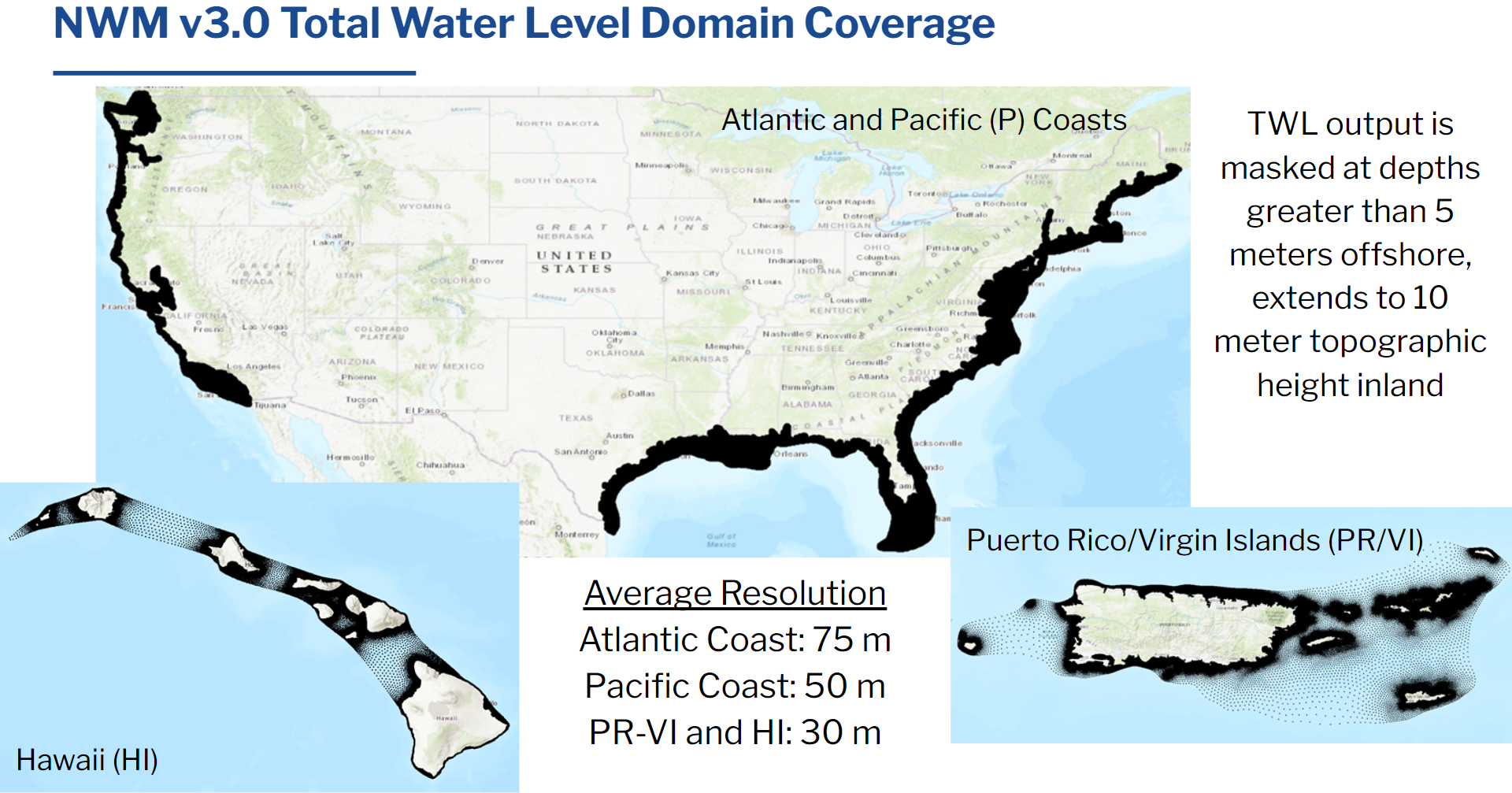
Starting with version 3.0 of the NWM, a new routing capability supports linkage of NWM freshwater modeling capabilities to a coastal-estuary model, the Semi-implicit Cross-scale Hydroscience Integrated System Model (SCHISM). Atmospheric forcing is drawn from the existing set of NWM forcing data described below, while ocean forcing is drawn from the Surge and Tide Operational Forecast System (STOFS) and Probabilistic Tropical Storm Surge (P-SURGE) models. This approach is applied over the East, Gulf and Pacific coasts of the CONUS, along with the coastlines of the Hawaii, Puerto Rico, and US Virgin Islands, within the Analysis and Assimilation, Short-Range, and Medium-Range forecast configurations. It provides enhanced guidance to emergency responders and improves the accuracy of NWM-based flood inundation maps along the coast.

Figure 1: Overview of NWM Total Water Level (TWL) modeling capability

Figure 2: NWM TWL modeling domain
Model Details:

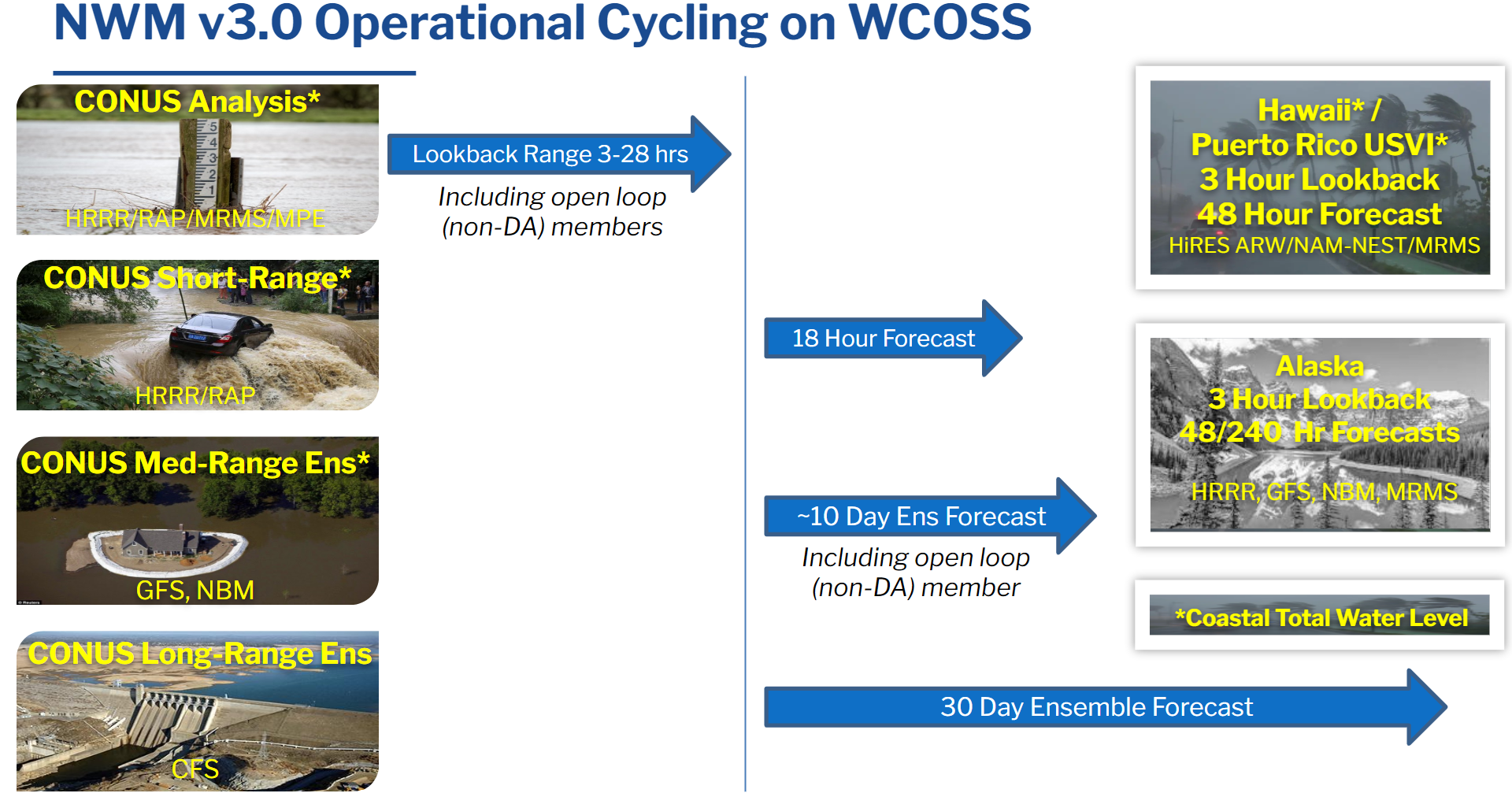
Figure 3: NWM v3.0 operational cycling
General Framework:
The NWM is run in multiple configurations as detailed below:- CONUS
- Streamflow
- Standard Analysis (self-cycling with 3-hour look-back, used to initialize CONUS short- and medium-range forecasts)
- Extended Analysis (28-hour lookback used to initialize Standard Analysis once per day)
- Open Loop Analysis (self-cycling with 3-hour look-back, used to initialize CONUS medium-range open loop forecasts, does not ingest streamflow observations)
- Long-Range Analysis (12-hour lookback, used to initialize Long-Range forecasts)
- Short-Range Forecast: 18-hour deterministic (single value) forecast
- Medium-Range Forecast: Six-member ensemble forecasts out to 10 days (member 1) and 8.5 days (members 2-6) initialized by standard analysis and forced by a time-lagged ensemble of GFS data
- Medium-Range Open Loop Forecast: 10-day deterministic (single value) forecast initialized by Open Loop Analysis
- Medium-Range Blend Forecast: 10-day deterministic (single value) forecast initialized by the standard Analysis and forced by the NBM (precip) and GFS
- Long-Range Forecast: 30-day four-member ensemble forecast
- Total Water Level
- Standard Analysis (self-cycling with 3-hour look-back, used to initialize CONUS short- and medium-range TWL forecasts)
- Extended Analysis (28-hour lookback used to initialize TWL Standard Analysis once per day)
- Short-Range Forecast: 18-hour deterministic (single value) TWL forecast with ingest of ocean boundary conditions from STOFS
- Medium-Range Forecast: 10-day deterministic (single value) TWL forecast with ingest of ocean boundary conditions from STOFS
- Short-Range PSURGE Forecast: 18-hour deterministic (single value) TWL forecast with ingest of ocean boundary conditions from both STOFS and PSURGE
- Medium-Range PSURGE Forecast: 10-day deterministic (single value) TWL forecast with ingest of ocean boundary conditions from both STOFS and PSURGE
- Streamflow
- Hawaii
- Streamflow
- Hawaii Analysis (self-cycling with 3-hour look-back, used to initialize Hawaii short-range forecasts)
- Hawaii Open-Loop Analysis (self-cycling with 3-hour look-back, used to initialize Hawaii short-range open-loop forecasts, does not ingest streamflow observations)
- Hawaii Short-Range Open Loop Forecast: 48-hour deterministic (single value) forecast for Hawaii domain, initialized with Open-Loop Analysis.
- Hawaii Short-Range Forecast: 48-hour deterministic (single value) forecast for Hawaii domain
- Total Water Level
- Standard Analysis (self-cycling with 3-hour look-back, used to initialize Hawaii short- and medium-range TWL forecasts)
- Short-Range Forecast: 48-hour deterministic (single value) TWL forecast with ingest of ocean boundary conditions from STOFS
- Medium-Range Forecast: 10-day deterministic (single value) TWL forecast with ingest of ocean boundary conditions from STOFS
- Streamflow
- Puerto Rico / USVI
- Streamflow
- Puerto Rico Analysis (self-cycling with 3-hour look-back, used to initialize Puerto Rico short-range forecasts)
- Puerto Rico Open-Loop Analysis (self-cycling with 3-hour look-back, used to initialize Puerto Rico short-range open-loop forecasts, does not ingest streamflow observations)
- Puerto Rico Short-Range Forecast: 48-hour deterministic (single value) forecast for Puerto Rico domain
- Puerto Rico Short-Range Open Loop Forecast: 48-hour deterministic (single value) forecast for Puerto Rico domain, initialized with Open-Loop Analysis.
- Total Water Level
- Standard Analysis (self-cycling with 3-hour look-back, used to initialize Hawaii short- and medium-range TWL forecasts)
- Short-Range Forecast: 48-hour deterministic (single value) TWL forecast with ingest of ocean boundary conditions from STOFS
- Medium-Range Forecast: 10-day deterministic (single value) TWL forecast with ingest of ocean boundary conditions from STOFS
- Streamflow
- Alaska
- Streamflow
- Alaska Analysis (self-cycling with 3-hour look-back, used to initialize Alaska short- and medium-range forecasts)
- Alaska Open-Loop Analysis (self-cycling with 3-hour look-back, used to initialize Alaska medium-range open-loop forecasts, does not ingest streamflow observations)
- Alaska Short-Range Forecast: 15-hour (0/6/12/18Z cycles) and 45-hour (3/9/15/21Z cycles) deterministic (single value) forecast for Alaska domain
- Alaska Medium-Range Open Loop Forecast: 240-hour deterministic (single value) forecast for Alaska domain, initialized with Open-Loop Analysis.
- Alaska Medium-Range Forecast: 240-hour deterministic (single value) forecast for Alaska domain
- Streamflow
Analysis and Assimilation Configurations:
CONUS
Standard Analysis and Assimilation
The Standard Analysis and Assimilation configuration cycles hourly and produces a real-time analysis of the current streamflow and other surface and near-surface hydrologic states across the contiguous United States (CONUS). This configuration is internally cycling, with each subsequent Standard Analysis starting from the previous hour’s run. The exception is the 19Z Standard Analysis cycle which ingests initial conditions from the Extended Analysis below. The Standard Analysis also produces restart files each hour which are used to initialize the short-, medium-, and long-range forecast simulations. Meteorological forcing data are drawn from the MRMS Gauge-adjusted and Radar-only observed precipitation products along with short-range RAP and HRRR, while stream-gauge observations are assimilated from the USGS.
Standard Open Loop Analysis and Assimilation
Identical to the Standard Analysis and Assimilation configuration above, but without the assimilation of USGS, USACE and RFC streamflow data. This configuration initializes the Open Loop Medium-Range forecast.
Extended Analysis and Assimilation
The Extended Analysis and Assimilation configuration cycles once per day and produces an analysis of the current streamflow and other surface and near-surface hydrologic states across the contiguous United States (CONUS). This configuration is internally cycling, with each subsequent Extended Analysis starting from the previous day’s run. This configuration also produces restart files which are used to initialize the 19Z Standard Analysis simulation. Meteorological forcing data are drawn from the Stage IV national mosaic of RFC MPE precipitation data along with short-range RAP and HRRR data.
Extended Open Loop Analysis and Assimilation
Identical to the Extended Analysis and Assimilation configuration above, but without the assimilation of USGS, USACE and RFC streamflow data. This configuration initializes the 19Z Open Loop Analysis simulation.
Long-Range Analysis and Assimilation
The Long-Range Analysis and Assimilation configuration cycles hourly and produces a real-time analysis of the current streamflow and other surface and near-surface hydrologic states across the contiguous United States (CONUS), using higher quality precipitation data than is available to the Standard Analysis and Assimilation. This configuration is internally cycling, with each subsequent Long-Range Analysis Standard Analysis starting from the previous hour’s run. The Long-Range Analysis also produces restart files which are used to initialize the long-range forecast simulations. Like the Long-Range configuration, it uses a simplified set of physics in comparison to the Standard and Extended Analyses. Meteorological forcing data are drawn from the MRMS Gauge-adjusted and Radar-only observed precipitation products along with short-range RAP and HRRR, while stream-gauge observations are assimilated from the USGS.
Long-Range Open Loop Analysis and Assimilation
Identical to the Long-Range Analysis and Assimilation configuration above, but without the assimilation of USGS streamflow data.
CONUS
Hawaii Analysis and Assimilation
The Hawaii Analysis and Assimilation configuration cycles hourly and produces a real-time analysis of the current streamflow and other surface and near-surface hydrologic states across the Hawaii domain. This configuration is internally cycling, with each subsequent Hawaii Analysis starting from the previous hour’s run. The Hawaii Analysis also produces restart files each hour which are used to initialize the Hawaii Short-Range forecast simulation. Meteorological forcing data are drawn from the MRMS Gauge-adjusted and Radar-only observed precipitation products along with additional fields from the NAM-NEST NWP Model, while stream-gauge observations are assimilated from the USGS.
Hawaii Open Loop Analysis and Assimilation
Identical to the Hawaii Analysis and Assimilation configuration above, but without the assimilation of USGS streamflow data. This configuration initializes the Open Loop Hawaii Short-Range forecast.
Puerto Rico / USVI
Puerto Rico / USVI Analysis and Assimilation
The Puerto Rico Analysis and Assimilation configuration cycles hourly and produces a real-time analysis of the current streamflow and other surface and near-surface hydrologic states across the Puerto Rico domain. This configuration is internally cycling, with each subsequent Puerto Rico Analysis starting from the previous hour’s run. The Puerto Analysis also produces restart files each hour which are used to initialize the Puerto Short-Range forecast simulation. Meteorological forcing data are drawn from the MRMS Gauge-adjusted and Radar-only observed precipitation products along with additional fields from the NAM-NEST NWP Model, while stream-gauge observations are assimilated from the USGS.
Puerto Rico / USVI Open Loop Analysis and Assimilation
Identical to the Puerto Rico Analysis and Assimilation configuration above, but without the assimilation of USGS streamflow data. This configuration initializes the Open Loop Puerto Rico Short-Range forecast.
Alaska
Alaska Analysis and Assimilation
The Alaska Analysis and Assimilation configuration cycles hourly and produces a real-time analysis of the current streamflow and other surface and near-surface hydrologic states across the Alaska domain. This configuration is internally cycling, with each subsequent Alaska Analysis starting from the previous hour’s run. The Alaska Analysis also produces restart files each hour which are used to initialize the Alaska Short- and Medium-Range forecast simulations. Meteorological forcing data are drawn from the MRMS Gauge-adjusted and Radar-only observed precipitation products along with HRRR-AK NWP Model, while stream-gauge observations are assimilated from the USGS.
Alaska Open Loop Analysis and Assimilation
Identical to the Alaska Analysis and Assimilation configuration above, but without the assimilation of USGS streamflow data. This configuration initializes the Open Loop Alaska Medium-Range forecast.
Alaska Extended Analysis and Assimilation
The Extended Analysis and Assimilation configuration cycles once per day and produces an analysis of the current streamflow and other surface and near-surface hydrologic states across the Alaska domain. This configuration is internally cycling, with each subsequent Extended Analysis starting from the previous day’s run. This configuration also produces restart files which are used to initialize the 23Z Standard Analysis simulation. Meteorological forcing data are drawn from Alaska Pacific RFC MPE precipitation data along with the HRRR-AK NWP model.
Alaska Extended Open Loop Analysis and Assimilation
Identical to the Extended Analysis and Assimilation configuration above, but without the assimilation of USGS, USACE and RFC streamflow data. This configuration initializes the 23Z Open Loop Analysis simulation.
Forecast Configurations:
Short Range
Forced with meteorological data from the HRRR and RAP models, the Short Range Forecast configuration cycles hourly and produces hourly deterministic forecasts of streamflow and hydrologic states out to 18 hours. The model is initialized with a restart file from the Analysis and Assimilation configuration and does not cycle on its own states.
Medium Range
The Medium Range Forecast configuration is executed four times per day, forced with GFS model output. Member 1 extends out to 10 days while members 2-6 extend out to 8.5 days. This configuration produces hourly and 3-hourly deterministic output and is initialized with the restart file from the Analysis and Assimilation configuration.
Medium-Range Open Loop
The Medium-Range open loop deterministic forecast configuration is executed four times per day using the same forcing as member 1 of the medium-range configuration, but drawing initial conditions from the Open Loop Analysis and Assimilation.
Medium Range Blend
The Medium Range Blend Forecast configuration is executed four times per day, forced with output from the NBM (precip) and GFS (other fields) models. This run extends out to 10 days in forecast length. This configuration produces hourly and 3-hourly deterministic output and is initialized with the restart file from the Analysis and Assimilation configuration.
Long Range
The Long Range Forecast cycles four times per day (i.e. every 6 hours) and produces a daily 16-member 30-day ensemble forecast. There are 4 ensemble members in each cycle of this forecast configuration, each forced with a different CFS forecast member. It produces 6-hourly streamflow and daily land surface output, and, as with the other forecast configurations, is initialized with a common restart file from the Analysis and Assimilation configuration.
Hawaii
Hawaii Short Range
Forced with meteorological data from the NAM-NEST (SW and LW) and WRF-ARW (all other fields) models, the Hawaii Short Range Forecast configuration cycles two times per day (00Z and 12Z) and produces hourly deterministic forecasts of streamflow and hydrologic states out to 48 hours. The model is initialized with a restart file from the Hawaii Analysis and Assimilation configuration and does not cycle on its own states.
Hawaii Short-Range Open Loop
The Hawaii Short-Range open loop deterministic forecast configuration is executed two times per day (00Z and 18Z) using the same forcing as the Hawaii Short-Range standard configuration, but drawing initial conditions from the Hawaii Open Loop Analysis and Assimilation.
Puerto Rico / USVI Short Range
Forced with meteorological data from the NAM-NEST (SW and LW) and WRF-ARW (all other fields) models, the Puerto Rico Short Range Forecast configuration cycles two times per day (06Z and 18Z) and produces hourly deterministic forecasts of streamflow and hydrologic states out to 48 hours. The model is initialized with a restart file from the Puerto Rico Analysis and Assimilation configuration and does not cycle on its own states.
Puerto Rico / USVI Short-Range Open Loop
The Puerto Rico Short-Range open loop deterministic forecast configuration is executed two times per day (06Z and 18Z) using the same forcing as the Puerto Rico Short-Range standard configuration, but drawing initial conditions from the Puerto Rico Open Loop Analysis and Assimilation.
Alaska
Alaska Short Range
Forced with meteorological data from the HRRR-AK and NBM, the Short Range Forecast configuration cycles every three hours and produces hourly deterministic forecasts of streamflow and hydrologic states out to 15-hours (0/6/12/18Z cycles) and 45-hours (3/9/15/21Z cycles). The model is initialized with a restart file from the Analysis and Assimilation configuration and does not cycle on its own states.
Alaska Medium Range
The Medium Range Forecast configuration is executed four times per day, forced with GFS model output. Member 1 extends out to 10 days while members 2-6 extend out to 8.5 days. This configuration produces hourly and 3-hourly deterministic output and is initialized with the restart file from the Analysis and Assimilation configuration.
Medium-Range Open Loop
The Medium-Range open loop deterministic forecast configuration is executed four times per day using the same forcing as member 1 of the medium-range configuration, but drawing initial conditions from the Open Loop Analysis and Assimilation.
Alaska Medium Range Blend
The Medium Range Blend Forecast configuration is executed four times per day, forced with output from the NBM (precip) and GFS (other fields) models. This run extends out to 10 days in forecast length. This configuration produces hourly and 3-hourly deterministic output and is initialized with the restart file from the Analysis and Assimilation configuration.
Output:
All NWM output will be stored in NetCDF format in one of three file types:
- 1km gridded NetCDF (land surface variables and forcing)
- 100m/250m gridded NetCDF (ponded water depth and depth to soil saturation)
- Point-type NetCDF (stream routing and reservoir variables)
The two gridded file types are used for four separate rectangular domains, 1) the CONUS+ (roughly from 19N to 58N) and 2) the Hawaiian Islands, 3) Puerto Rico / USVI and 4) southern Alaska, while the point NetCDF file type is used for a similar set of four regions including 1) the CONUS (including adjacent hydrologically contributing areas), 2) the Hawaiian Islands, 3) Puerto Rico / USVI and 4) southern Alaska.
NWM total water level output is provided in both NetCDF as well as SHEF format. Each NetCDF file contains full TWL domain output for one output time step, while each SHEF file contains timeseries station output for the full length of each simulation.
Output File Contents:
A full breakdown of output file contents can be found here.
Viewing Output:
Output from the National Water Model is currently visualized on this website using the experimental interactive map, and the experimental image viewer.
Downloading Output:
The full set of NWM output data and a subset of forcing files is available on the NOAA Operational Model Archive and Distribution System (NOMADS) and the National Centers for Environmental Prediction (NCEP) FTP server at the following links:
Most NWM NetCDF output files are directly viewable using standard NetCDF visualization utilities. The exception are the channel output files containing streamflow and other variables representing processes along river reach segments. To support visualization of these variables, the latitude and longitude coordinates of the centroid of each reach are made available in a separate ESRI file geo-database (gdb), outside of the NWM outputs. The file gdb can be used in many common GIS software utilities to attach coordinates to the data. The file gdb is available here.
NCEP encourages all users to ensure their decoders are flexible and are able to adequately handle changes in content order and also any volume changes which may be forthcoming. These elements may change with future NCEP model implementations. NCEP will make every attempt to alert users to these changes prior to any implementations.
To learn more about the NOAA's National Water Model, click here.
Parameter Information:
A subset of the NWM model and coastal module parameter files used by the operational implementation of the NWM is available. To download a tar file of the available NWM parameter files, click here, and to download the coastal module parameters, click here. A description of the NWM and coastal parameters can be found here.
Further Technical Information
Further information will be available via the NWM overview article, "NOAA's National Water Model: Advancing Operational Hydrology Through Continental-Scale Modeling", (Cosgrove et al., 2023), in preparation for publication in the Journal of the American Water Resources Association.