Short-term Probabilistic Guidance Product
What
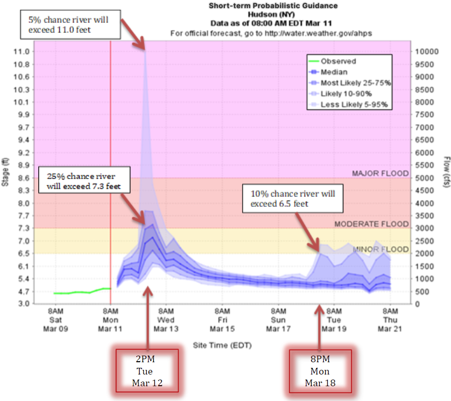
The Short-Term Probabilistic Guidance Product contains a
graphical depiction of the short-range (0-10 days) river forecast uncertainty
predicted by the HEFS. At each forecast time-step (typically every 6 hours),
the graphic conveys a range of possible river stages, and corresponding flows,
at a particular forecast location. These possibilities are shaded using
different categories of forecast probability, ranging from most likely to less
likely. These probability ranges (uncertainty bounds) are derived from the ensemble
forecasts produced by HEFS at each forecast time-step.
In the example below, the forecast for 2pm EDT on March 12 indicates
a roughly 25% chance that the river level will exceed 7.3 feet (Moderate Flooding).
It also indicates a roughly 5% chance that the river will exceed 11.0 feet
(above the Major Flooding level).
Also, the forecast for 8pm EDT on March 18 indicates a
roughly 10% chance that the river will exceed 6.5 feet (Minor Flooding) at that
time in the forecast horizon.
How
Ensemble forecasting is a practical and effective approach
to quantifying uncertainty. In contrast to single-valued forecasts, ensemble
forecasts provide a collection of possibilities. Each ensemble member
represents one possible and equally likely outcome and, collectively, all of
the ensemble members aim to capture the range of possible outcomes and their
associated probabilities.
If the total uncertainty is not adequately quantified, the
forecast probabilities will not be sufficiently accurate; in other words the
ensemble spread will not consistently “capture” the observed streamflow. The
uncertainty in our river forecasts originates from two main sources: 1) weather
forecasting or “forcing” uncertainty (i.e., uncertainty about the future values
of temperature, precipitation and any other forcing variables used by the
hydrologic models); and 2) hydrologic uncertainty (i.e., all of the
uncertainties associated with hydrologic modeling, including the initial
conditions, model parameters, model structure, etc.).
The NWS has developed and implemented the Hydrologic
Ensemble Forecast Service (HEFS), in order to produce accurate ensemble
forecasts that better quantify the uncertainties in our river forecasts. The
HEFS utilizes weather and climate forecasts from a variety of sources,
including the River Forecast Center (RFC) precipitation and temperature
forecasts, as well as ensemble mean forecasts from NWS numerical weather
prediction models. Biases in the weather forecasts are calculated and
corrections are applied. A post-processing option in the HEFS also provides the
capability to capture the hydrologic uncertainty in the streamflow predictions
and correct for biases in the forecast probabilities.
Why
The typical river forecasts produced by the NWS are
single-valued forecasts (example),
which are known to be imperfect. They are based on models with imperfect
descriptions of physical processes. They utilize parameters that are estimated
with limited data, and that limited data includes measurement and other
errors.
These imperfections are reflected in the differences between
the river forecasts and the corresponding river observations (at gage
locations). The differences generally increase with forecast lead time and can
be much larger for extreme events (e.g., floods). A single-valued forecast does
not provide information about the forecast uncertainty (i.e., the range of
possible outcomes and their associated probabilities).
Quantifying and providing explicit estimates of the
uncertainty in our river forecasts is one of the most pressing needs of
operational hydrologic forecasting. Ultimately, the goal is to support
informed, risk-based, management of water resources and hazards.