Tombigbee River at Gainesville Lock and Dam
Future / Actual / Minor
OWP 2.0 WWA Modal Title
01/11/2021, 10:04 PM UTC through 01/11/2021, 10:04 PM UTC
Sender
Sent
- Warning: no valid ratings curve available. Transformations to and from FEET/CFS/KCFS will not happen.
Traces and Thresholds Click to turn on/off display
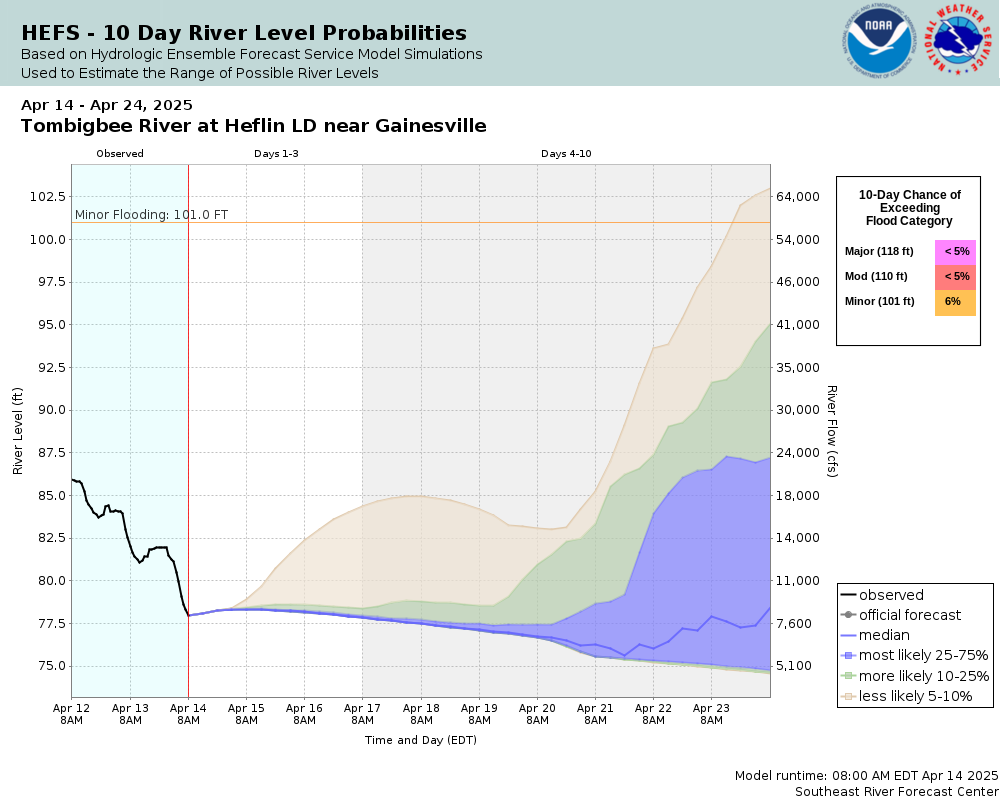
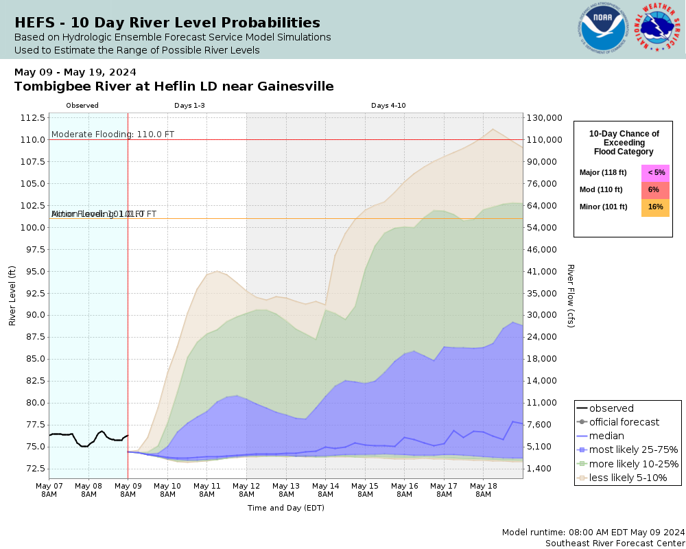
Observed (OBS) 04/06/2025 8:45 PM CDTOfficial Forecast (FCST) 04/06/2025 8:41 PM CDTRecord: 120.7 ftCATEGORY STAGE 
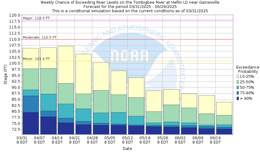
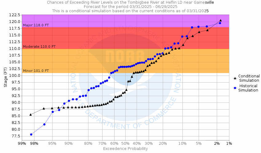
Major Flooding 118 ft Moderate Flooding 110 ft Minor Flooding 101 ft Action 101 ft Reliability of the Forecast:
NOTE: Forecasts are issued routinely year-round.
River forecasts for this location take into account past precipitation and the precipitation amounts expected approximately 48 hours into the future from the forecast issuance time.
National Water Model Hydrograph
Official NWS streamflow forecasts are produced by NWS hydrologic forecasters for river gauge locations using hydrologic models which are calibrated to that location. This process considers additional guidance and information, including local expertise and experience, to produce the best forecast possible. The NWM output provides supplemental guidance to NWS forecasters and should not be considered an official NWS river forecast.
Flood Impacts
- 117.5 - Flooding of some secondary homes upstream in the Panola and Warsaw areas occurs.
- 109 - Flooding of some camps and cabins...as well as widespread flooding of low-lying woods and agricultural lands...occurs, especially upstream of the lock and dam.
- 101 - Flooding of low lying agricultural and wooded lands in the area occurs.
Gauge Location
Recent Crests
| 1. | 102.75 ft | on 02-26-2022 |
| 2. | 116.58 ft | on 02-16-2020 |
| 3. | 105.08 ft | on 04-16-2019 |
| 4. | 115.46 ft | on 02-28-2019 |
| 5. | 104.22 ft | on 12-29-2018 |
Recent Crests
| 1. | 102.75 ft | on 02-26-2022 |
| 2. | 116.58 ft | on 02-16-2020 |
| 3. | 105.08 ft | on 04-16-2019 |
| 4. | 115.46 ft | on 02-28-2019 |
| 5. | 104.22 ft | on 12-29-2018 |
| 6. | 102.41 ft | on 02-12-2018 |
| 7. | 109.41 ft | on 04-04-2017 |
| 8. | 109.18 ft | on 12-30-2016 |
| 9. | 101.16 ft | on 03-12-2016 |
| 10. | 107.03 ft | on 12-30-2015 |
| 11. | 103.78 ft | on 01-04-2015 |
| 12. | 108.33 ft | on 04-09-2014 |
| 13. | 102.10 ft | on 04-23-2011 |
| 14. | 106.40 ft | on 03-11-2011 |
| 15. | 109.43 ft | on 03-10-2011 |
| 16. | 109.29 ft | on 12-10-2010 |
| 17. | 109.46 ft | on 03-01-2009 |
| 18. | 107.73 ft | on 01-10-2009 |
| 19. | 105.63 ft | on 12-14-2008 |
| 20. | 109.44 ft | on 03-04-2008 |
| 21. | 113.56 ft | on 12-11-2005 |
| 22. | 112.01 ft | on 12-14-2004 |
| 23. | 108.83 ft | on 02-12-2004 |
| 24. | 112.95 ft | on 02-09-2004 |
| 25. | 104.55 ft | on 04-09-2003 |
| 26. | 110.04 ft | on 02-25-2003 |
| 27. | 111.55 ft | on 02-24-2003 |
| 28. | 109.05 ft | on 01-29-2002 |
| 29. | 106.50 ft | on 12-17-2001 |
| 30. | 102.08 ft | on 01-22-2001 |
| 31. | 103.50 ft | on 04-10-2000 |
| 32. | 109.92 ft | on 02-02-1999 |
| 33. | 106.60 ft | on 01-27-1999 |
| 34. | 102.86 ft | on 03-10-1998 |
| 35. | 110.75 ft | on 01-09-1998 |
| 36. | 104.50 ft | on 03-07-1997 |
| 37. | 104.62 ft | on 01-28-1996 |
| 38. | 109.92 ft | on 04-26-1995 |
| 39. | 110.31 ft | on 03-11-1995 |
| 40. | 99.61 ft | on 02-18-1995 |
| 41. | 107.62 ft | on 03-31-1994 |
| 42. | 109.79 ft | on 02-15-1994 |
| 43. | 107.62 ft | on 12-07-1991 |
| 44. | 116.50 ft | on 06-01-1991 |
| 45. | 112.80 ft | on 05-17-1991 |
| 46. | 114.88 ft | on 05-04-1991 |
| 47. | 118.35 ft | on 02-25-1991 |
| 48. | 114.82 ft | on 12-28-1990 |
| 49. | 105.62 ft | on 03-07-1989 |
| 50. | 110.94 ft | on 01-17-1989 |
| 51. | 109.60 ft | on 03-03-1987 |
| 52. | 103.01 ft | on 01-20-1987 |
| 53. | 120.74 ft | on 04-15-1979 |
Historic Crests
| 1. | 120.74 ft | on 04-15-1979 |
| 2. | 118.35 ft | on 02-25-1991 |
| 3. | 116.58 ft | on 02-16-2020 |
| 4. | 116.50 ft | on 06-01-1991 |
| 5. | 115.46 ft | on 02-28-2019 |
Historic Crests
| 1. | 120.74 ft | on 04-15-1979 |
| 2. | 118.35 ft | on 02-25-1991 |
| 3. | 116.58 ft | on 02-16-2020 |
| 4. | 116.50 ft | on 06-01-1991 |
| 5. | 115.46 ft | on 02-28-2019 |
| 6. | 114.88 ft | on 05-04-1991 |
| 7. | 114.82 ft | on 12-28-1990 |
| 8. | 113.56 ft | on 12-11-2005 |
| 9. | 112.95 ft | on 02-09-2004 |
| 10. | 112.80 ft | on 05-17-1991 |
| 11. | 112.01 ft | on 12-14-2004 |
| 12. | 111.55 ft | on 02-24-2003 |
| 13. | 110.94 ft | on 01-17-1989 |
| 14. | 110.75 ft | on 01-09-1998 |
| 15. | 110.31 ft | on 03-11-1995 |
| 16. | 110.04 ft | on 02-25-2003 |
| 17. | 109.92 ft | on 02-02-1999 |
| 18. | 109.92 ft | on 04-26-1995 |
| 19. | 109.79 ft | on 02-15-1994 |
| 20. | 109.60 ft | on 03-03-1987 |
| 21. | 109.46 ft | on 03-01-2009 |
| 22. | 109.44 ft | on 03-04-2008 |
| 23. | 109.43 ft | on 03-10-2011 |
| 24. | 109.41 ft | on 04-04-2017 |
| 25. | 109.29 ft | on 12-10-2010 |
| 26. | 109.18 ft | on 12-30-2016 |
| 27. | 109.05 ft | on 01-29-2002 |
| 28. | 108.83 ft | on 02-12-2004 |
| 29. | 108.33 ft | on 04-09-2014 |
| 30. | 107.73 ft | on 01-10-2009 |
| 31. | 107.62 ft | on 03-31-1994 |
| 32. | 107.62 ft | on 12-07-1991 |
| 33. | 107.03 ft | on 12-30-2015 |
| 34. | 106.60 ft | on 01-27-1999 |
| 35. | 106.50 ft | on 12-17-2001 |
| 36. | 106.40 ft | on 03-11-2011 |
| 37. | 105.63 ft | on 12-14-2008 |
| 38. | 105.62 ft | on 03-07-1989 |
| 39. | 105.08 ft | on 04-16-2019 |
| 40. | 104.62 ft | on 01-28-1996 |
| 41. | 104.55 ft | on 04-09-2003 |
| 42. | 104.50 ft | on 03-07-1997 |
| 43. | 104.22 ft | on 12-29-2018 |
| 44. | 103.78 ft | on 01-04-2015 |
| 45. | 103.50 ft | on 04-10-2000 |
| 46. | 103.01 ft | on 01-20-1987 |
| 47. | 102.86 ft | on 03-10-1998 |
| 48. | 102.75 ft | on 02-26-2022 |
| 49. | 102.41 ft | on 02-12-2018 |
| 50. | 102.10 ft | on 04-23-2011 |
| 51. | 102.08 ft | on 01-22-2001 |
| 52. | 101.16 ft | on 03-12-2016 |
| 53. | 99.61 ft | on 02-18-1995 |
Gauge Photos
No Images Found

Unique Local Info
|
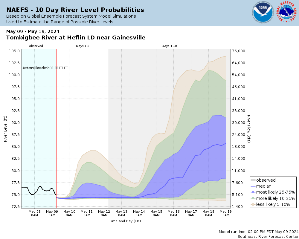
Potential River Levels Used to Estimate the Chance of Flooding and the Range of Possible River Levels |
||
| 10 Day (HEFS) | 7 Day (NAEFS) | 7 Day (GEFS) |
 |
 |
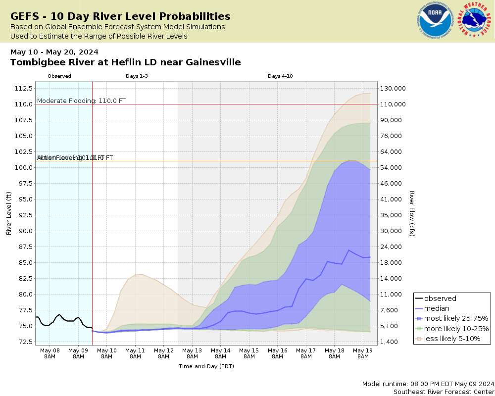 |
Note: Use the official hydrograph at the top of this web page for river levels within the next 72 Hours.
Collaborative Agencies
The National Weather Service prepares its forecasts and other services in collaboration with agencies like the US Geological Survey, US Bureau of Reclamation, US Army Corps of Engineers, Natural Resource Conservation Service, National Park Service, ALERT Users Group, Bureau of Indian Affairs, and many state and local emergency managers across the country. For details, please click here.