St. Joseph River (OH/IN) near Fort Wayne
Future / Actual / Minor
OWP 2.0 WWA Modal Title
01/11/2021, 10:04 PM UTC through 01/11/2021, 10:04 PM UTC
Sender
Sent
- Warning: no valid ratings curve available. Transformations to and from FEET/CFS/KCFS will not happen.
Traces and Thresholds Click to turn on/off display
Observed (OBS) 04/14/2025 2:55 AM EDTRecord: 22 ftCATEGORY STAGE 
Major Flooding 20 ft Moderate Flooding 18 ft Minor Flooding 12 ft Action 10 ft Reliability of the Forecast:
NOTE: Forecasts are issued as needed during times of high water, but are not routinely available.
River forecasts for this location take into account past precipitation and the precipitation amounts expected approximately 48 hours into the future from the forecast issuance time.
National Water Model Hydrograph
Official NWS streamflow forecasts are produced by NWS hydrologic forecasters for river gauge locations using hydrologic models which are calibrated to that location. This process considers additional guidance and information, including local expertise and experience, to produce the best forecast possible. The NWM output provides supplemental guidance to NWS forecasters and should not be considered an official NWS river forecast.
Flood Impacts
- 20 - A major flood is in progress and water nears the top of uncertified levees.
- 19 - An increasing number of city streets flood with a few homes in Concordia Gardens affected by high water.
- 18 - The city of Fort Wayne starts monitoring all potential flood sites on the St. Joseph River. Some residents in low lying areas and Canterbury Green Apartments will be affected by high water.
Gauge Info
| Coordinates | 41.1675, -85.0742 |
| RFC | OHRFC |
| State | IN |
| WFO | IWX |
| County | Allen |
| Data Provider(s) | |
| the USGS (04180500) | Jump to USGS site |
| USGS | 04180500 |
Gauge Location
Recent Crests
| 1. | 8.65 ft | on 05-10-2021 |
| 2. | 11.44 ft | on 01-12-2020 |
| 3. | 11.23 ft | on 05-02-2019 |
| 4. | 14.24 ft | on 02-22-2018 |
| 5. | 11.48 ft | on 05-25-2017 |
Recent Crests
| 1. | 8.65 ft | on 05-10-2021 |
| 2. | 11.44 ft | on 01-12-2020 |
| 3. | 11.23 ft | on 05-02-2019 |
| 4. | 14.24 ft | on 02-22-2018 |
| 5. | 11.48 ft | on 05-25-2017 |
| 6. | 13.35 ft | on 06-28-2015 |
| 7. | 13.38 ft | on 06-18-2015 |
| 8. | 13.97 ft | on 04-04-2014 |
| 9. | 13.12 ft | on 06-01-2013 |
| 10. | 16.01 ft | on 04-20-2013 |
| 11. | 17.67 ft | on 12-01-2011 |
| 12. | 14.48 ft | on 05-27-2011 |
| 13. | 12.16 ft | on 04-23-2011 |
| 14. | 12.68 ft | on 03-06-2011 |
| 15. | 14.88 ft | on 05-22-2010 |
| 16. | 13.62 ft | on 04-07-2009 |
| 17. | 20.38 ft | on 03-12-2009 |
| 18. | 13.97 ft | on 02-12-2009 |
| 19. | 12.84 ft | on 12-28-2008 |
| 20. | 17.37 ft | on 02-07-2008 |
| 21. | 16.38 ft | on 01-09-2008 |
| 22. | 12.11 ft | on 12-23-2007 |
| 23. | 12.00 ft | on 12-12-2007 |
| 24. | 11.97 ft | on 04-28-2007 |
| 25. | 12.47 ft | on 01-16-2007 |
| 26. | 12.11 ft | on 12-02-2006 |
| 27. | 12.05 ft | on 03-14-2006 |
| 28. | 12.40 ft | on 02-15-2005 |
| 29. | 14.41 ft | on 01-14-2005 |
| 30. | 14.06 ft | on 06-14-2004 |
| 31. | 12.85 ft | on 06-12-2004 |
| 32. | 12.41 ft | on 05-31-2004 |
| 33. | 12.07 ft | on 05-10-2003 |
| 34. | 12.53 ft | on 05-17-2002 |
| 35. | 10.91 ft | on 05-13-2002 |
| 36. | 10.27 ft | on 04-03-2002 |
| 37. | 10.36 ft | on 03-31-2002 |
| 38. | 12.53 ft | on 02-01-2002 |
| 39. | 12.20 ft | on 10-17-2001 |
| 40. | 12.07 ft | on 10-17-2001 |
| 41. | 10.42 ft | on 02-26-2001 |
| 42. | 12.51 ft | on 02-15-2001 |
| 43. | 13.31 ft | on 02-11-2001 |
| 44. | 8.12 ft | on 09-13-2000 |
| 45. | 13.44 ft | on 04-24-1999 |
| 46. | 15.71 ft | on 01-25-1999 |
| 47. | 14.03 ft | on 01-09-1998 |
| 48. | 14.09 ft | on 02-27-1997 |
| 49. | 18.10 ft | on 05-19-1996 |
| 50. | 13.19 ft | on 04-10-1995 |
| 51. | -1.00 ft | on 04-13-1994 |
| 52. | 17.15 ft | on 01-05-1993 |
| 53. | 10.28 ft | on 10-27-1991 |
| 54. | 17.51 ft | on 12-31-1990 |
| 55. | 15.08 ft | on 02-24-1990 |
| 56. | 17.86 ft | on 06-05-1989 |
| 57. | 13.36 ft | on 10-05-1986 |
| 58. | 17.79 ft | on 02-26-1985 |
| 59. | 9.55 ft | on 03-04-1953 |
| 60. | 14.37 ft | on 02-23-1951 |
| 61. | 17.90 ft | on 04-07-1950 |
| 62. | 14.20 ft | on 02-16-1949 |
| 63. | 16.07 ft | on 05-20-1945 |
| 64. | 16.18 ft | on 04-12-1944 |
| 65. | 16.70 ft | on 05-18-1943 |
| 66. | 22.00 ft | on 03-26-1913 |
Historic Crests
| 1. | 22.00 ft | on 03-26-1913 |
| 2. | 20.38 ft | on 03-12-2009 |
| 3. | 18.10 ft | on 05-19-1996 |
| 4. | 17.90 ft | on 04-07-1950 |
| 5. | 17.86 ft | on 06-05-1989 |
Historic Crests
| 1. | 22.00 ft | on 03-26-1913 |
| 2. | 20.38 ft | on 03-12-2009 |
| 3. | 18.10 ft | on 05-19-1996 |
| 4. | 17.90 ft | on 04-07-1950 |
| 5. | 17.86 ft | on 06-05-1989 |
| 6. | 17.79 ft | on 02-26-1985 |
| 7. | 17.67 ft | on 12-01-2011 |
| 8. | 17.51 ft | on 12-31-1990 |
| 9. | 17.37 ft | on 02-07-2008 |
| 10. | 17.15 ft | on 01-05-1993 |
| 11. | 16.70 ft | on 05-18-1943 |
| 12. | 16.38 ft | on 01-09-2008 |
| 13. | 16.18 ft | on 04-12-1944 |
| 14. | 16.07 ft | on 05-20-1945 |
| 15. | 16.01 ft | on 04-20-2013 |
| 16. | 15.71 ft | on 01-25-1999 |
| 17. | 15.08 ft | on 02-24-1990 |
| 18. | 14.88 ft | on 05-22-2010 |
| 19. | 14.48 ft | on 05-27-2011 |
| 20. | 14.41 ft | on 01-14-2005 |
| 21. | 14.37 ft | on 02-23-1951 |
| 22. | 14.24 ft | on 02-22-2018 |
| 23. | 14.20 ft | on 02-16-1949 |
| 24. | 14.09 ft | on 02-27-1997 |
| 25. | 14.06 ft | on 06-14-2004 |
| 26. | 14.03 ft | on 01-09-1998 |
| 27. | 13.97 ft | on 04-04-2014 |
| 28. | 13.97 ft | on 02-12-2009 |
| 29. | 13.62 ft | on 04-07-2009 |
| 30. | 13.44 ft | on 04-24-1999 |
| 31. | 13.38 ft | on 06-18-2015 |
| 32. | 13.36 ft | on 10-05-1986 |
| 33. | 13.35 ft | on 06-28-2015 |
| 34. | 13.31 ft | on 02-11-2001 |
| 35. | 13.19 ft | on 04-10-1995 |
| 36. | 13.12 ft | on 06-01-2013 |
| 37. | 12.85 ft | on 06-12-2004 |
| 38. | 12.84 ft | on 12-28-2008 |
| 39. | 12.68 ft | on 03-06-2011 |
| 40. | 12.53 ft | on 05-17-2002 |
| 41. | 12.53 ft | on 02-01-2002 |
| 42. | 12.51 ft | on 02-15-2001 |
| 43. | 12.47 ft | on 01-16-2007 |
| 44. | 12.41 ft | on 05-31-2004 |
| 45. | 12.40 ft | on 02-15-2005 |
| 46. | 12.20 ft | on 10-17-2001 |
| 47. | 12.16 ft | on 04-23-2011 |
| 48. | 12.11 ft | on 12-23-2007 |
| 49. | 12.11 ft | on 12-02-2006 |
| 50. | 12.07 ft | on 05-10-2003 |
| 51. | 12.07 ft | on 10-17-2001 |
| 52. | 12.05 ft | on 03-14-2006 |
| 53. | 12.00 ft | on 12-12-2007 |
| 54. | 11.97 ft | on 04-28-2007 |
| 55. | 11.48 ft | on 05-25-2017 |
| 56. | 11.44 ft | on 01-12-2020 |
| 57. | 11.23 ft | on 05-02-2019 |
| 58. | 10.91 ft | on 05-13-2002 |
| 59. | 10.42 ft | on 02-26-2001 |
| 60. | 10.36 ft | on 03-31-2002 |
| 61. | 10.28 ft | on 10-27-1991 |
| 62. | 10.27 ft | on 04-03-2002 |
| 63. | 9.55 ft | on 03-04-1953 |
| 64. | 8.65 ft | on 05-10-2021 |
| 65. | 8.12 ft | on 09-13-2000 |
| 66. | -1.00 ft | on 04-13-1994 |
Vertical Datum Table
| type | NAVD88 |
|---|---|
| major Flooding | 772.99 ft |
| moderate Flooding | 770.99 ft |
| minor Flooding | 764.99 ft |
| action | 762.99 ft |
| Latest Value | 756.76 ft |
| Gauge Zero | 752.99 ft |


Unique Local Info
|
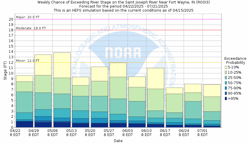
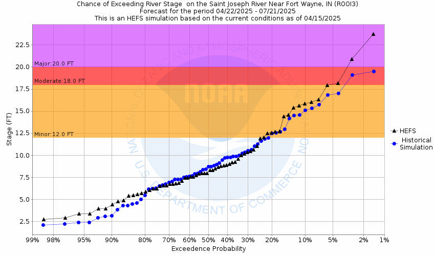
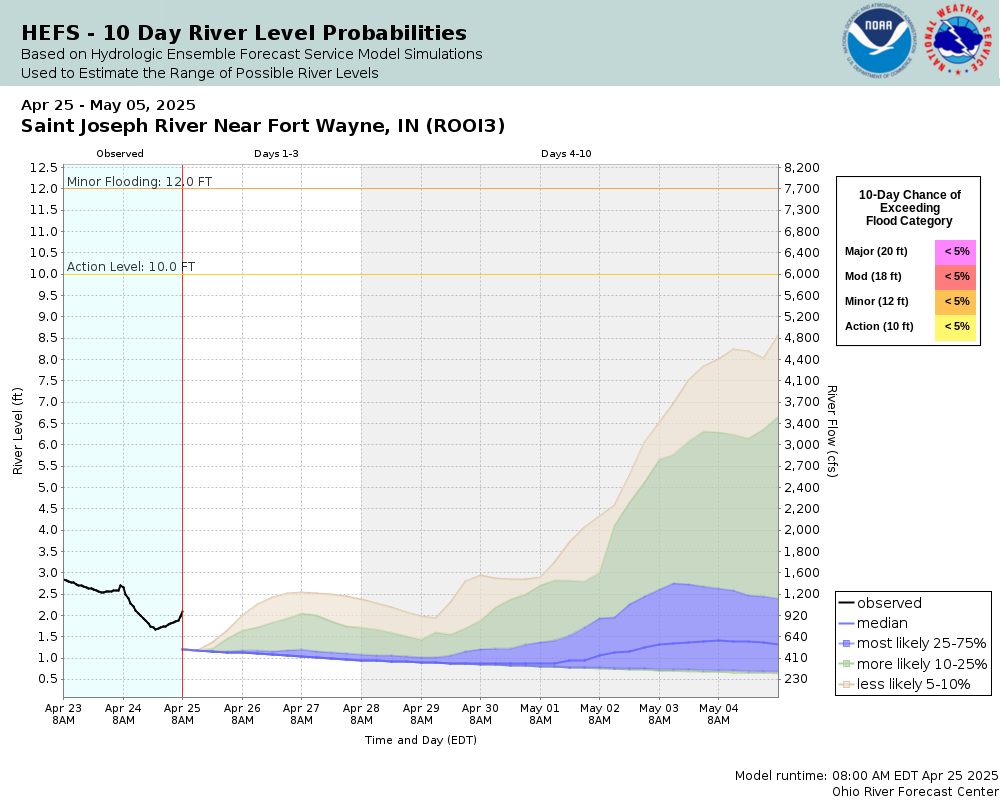
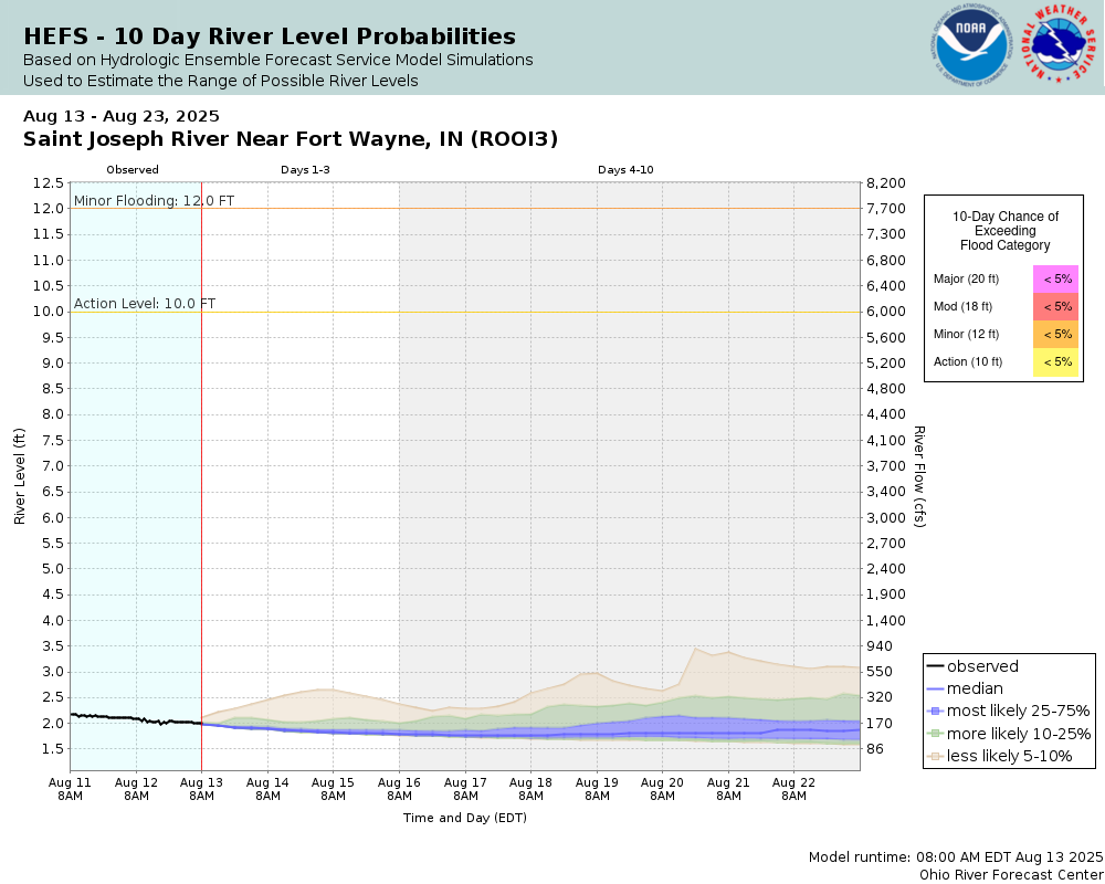
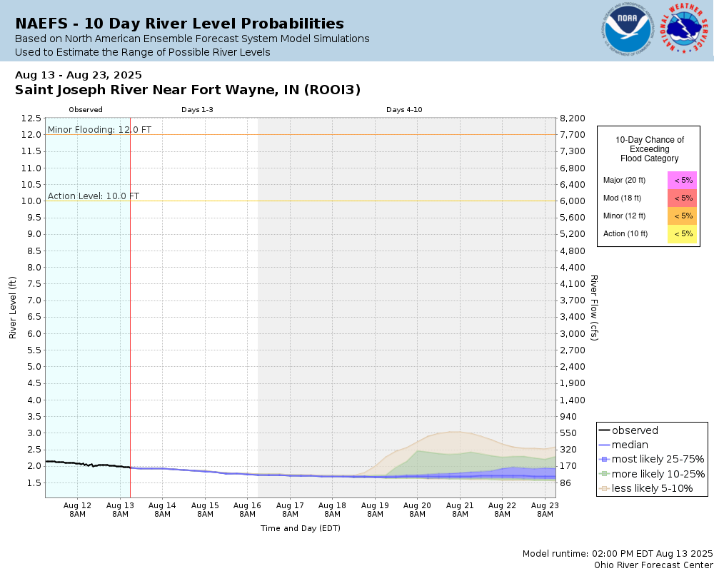
Potential River Levels Used to Estimate the Chance of Flooding and the Range of Possible River Levels |
||
| 10 Day (HEFS) | 10 Day (NAEFS) | River Forecast VS. River Potential |
 |
 |
 |
Note: Use the official hydrograph at the top of this web page for river levels within the next 72 hours.
Click individual graphics to enlarge.
Collaborative Agencies
The National Weather Service prepares its forecasts and other services in collaboration with agencies like the US Geological Survey, US Bureau of Reclamation, US Army Corps of Engineers, Natural Resource Conservation Service, National Park Service, ALERT Users Group, Bureau of Indian Affairs, and many state and local emergency managers across the country. For details, please click here.